


Heatmapping Invertebrate Records in the Burren
Client: National Parks and Wildlife Service (NPWS) | Delivered: May 2026 | With: Adam Mantell, Arctia Ecology
Overview
The NPWS commissioned BioSpatial Insights to create a rapid, repeatable method for mapping where invertebrate records exist across the Burren, to show where future survey effort would add the most. The method was developed and delivered in just a few days. It turns tens of thousands of records of mixed spatial precision into clear monad (1 km × 1 km) heatmaps for six major invertebrate groups and for saproxylic (decaying wood) invertebrates.
The challenge
The Burren is internationally renowned for its plants, but its invertebrates have been recorded unevenly. Records come from dozens of datasets and vary widely in precision, from ten-figure grid references to 10 km squares. The usual fix is to discard coarse records, which throws away useful data. The aim of this project was to use everything available and quickly show where the gaps are.
Approach
Data: About 73,000 records (1980–2025) from the National Biodiversity Data Centre and the Bees, Wasps and Ants Recording Society, including restricted datasets released with permission.
Standardisation: Taxon names were harmonised through the NBN API using bespoke R functions, so that synonyms didn’t inflate apparent richness.
Probabilistic downscaling: Records at monad resolution or better were assigned directly to a 1 km × 1 km square. Coarser records were spread across every square they could belong to, weighted by likelihood (a hectad record contributes 0.01 to each of its 100 monads, a tetrad record 0.25 to each of its 4). All usable data contributes without false precision.
Target groups: Spiders, beetles, flies, true bugs, wasps, bees and sawflies, and butterflies and moths, plus a saproxylic species list refined from Pantheon with expert review.
Delivery: The analysis ran in R and PostgreSQL/PostGIS, and was mapped in QGIS, across the 886 monads that cover the Burren.
Key findings
Recording was highly uneven. Coole–Garryland Nature Reserve, Dromore Woods, Ballyogan and Moyree Loughs, and parts of the Burren National Park stood out as hotspots across several groups.
Large areas were poorly recorded. Around 45% of monads in two hectads (M40 and M41) had no records of the target groups, and some monads inside the National Park had fewer than three recorded taxa.
Butterflies and moths dominated the data, accounting for 73% of all supplied records. Spiders, flies and true bugs have been comparatively overlooked, and the maps pinpoint where survey would help most.
The maps give a practical starting point for survey planning. Poorly recorded monads can be cross-referenced with habitat quality to pick candidate sites.
Next steps
The code base makes the approach quick to repeat for other taxonomic groups, assemblages (such as turlough or grassland invertebrates) or new areas, and to rerun as new records become available. Planned work will build on this foundation by extending coverage to further groups.
Tools: R, PostgreSQL/PostGIS, QGIS, NBN API
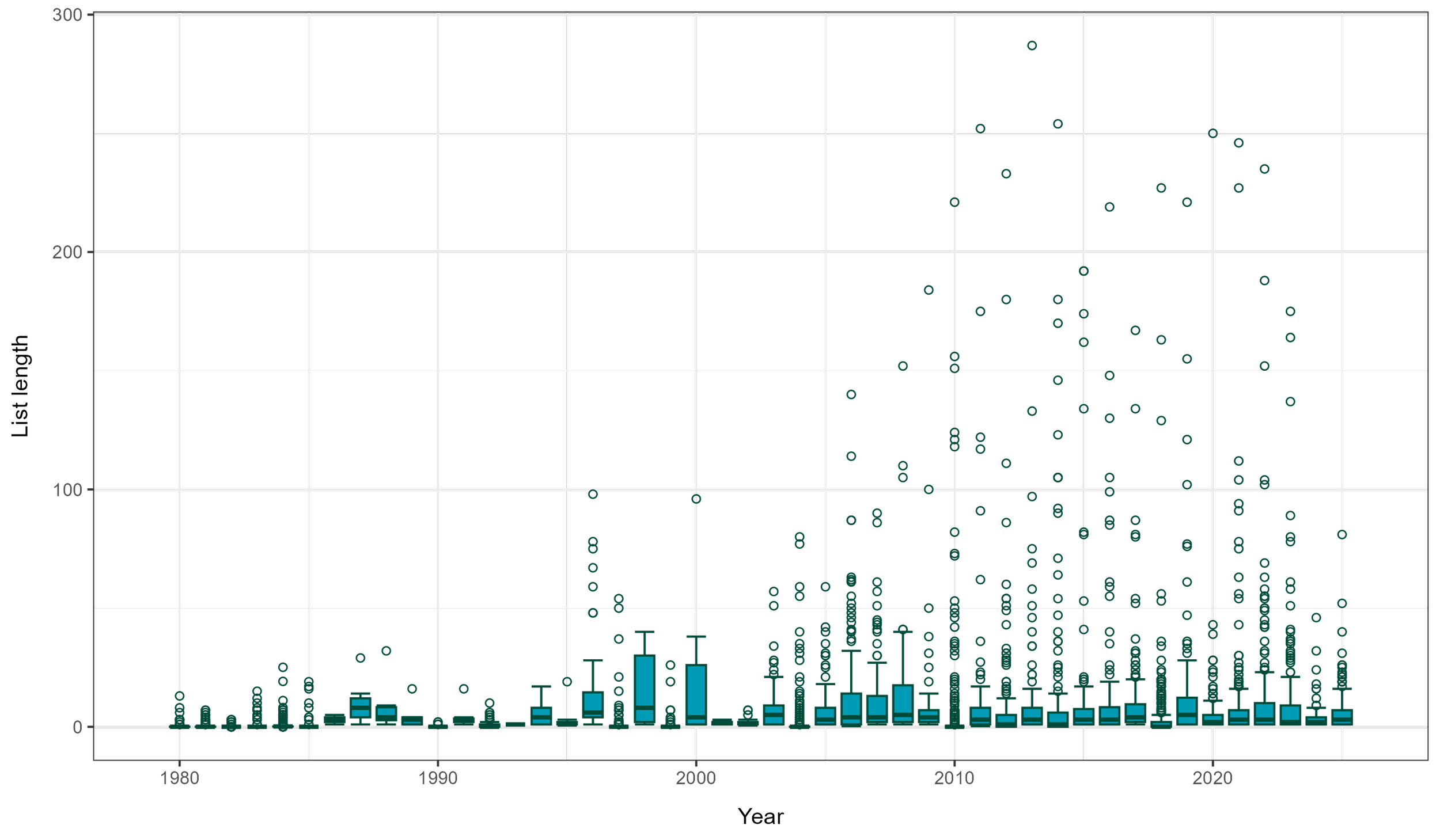
Average list length per monad per year since 1980 for the six invertebrate groups targeted by this study.
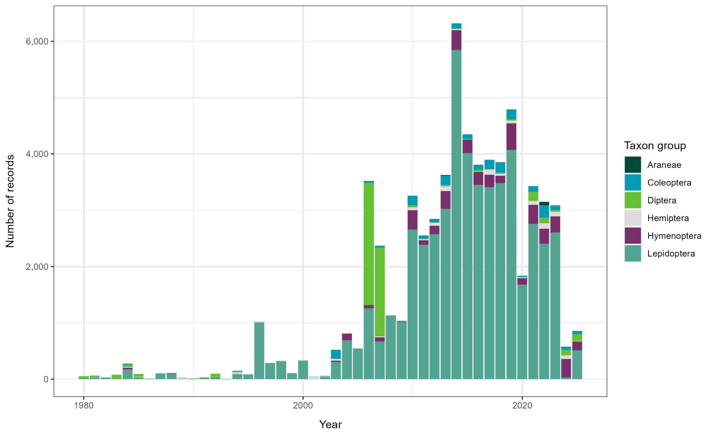
Number of records per year since 1980 for the six invertebrate groups targeted by this study.
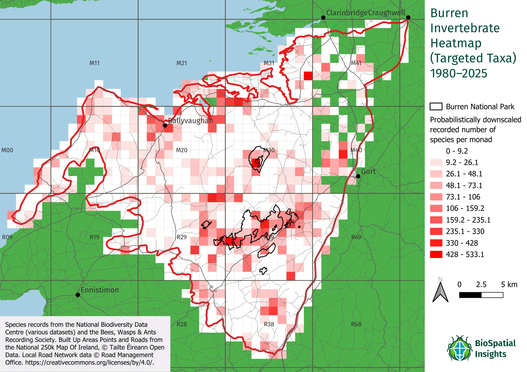
Heatmap for the six targeted invertebrate groups in the Burren.
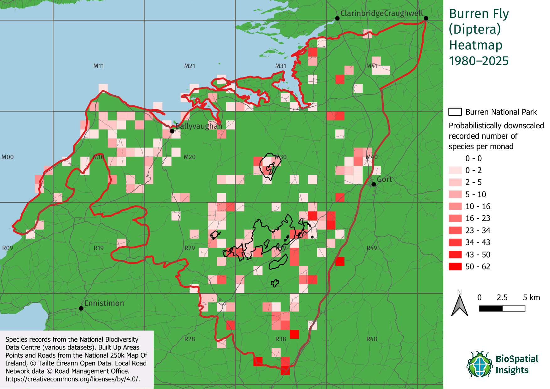
Heatmap for true flies (Diptera) in the Burren.
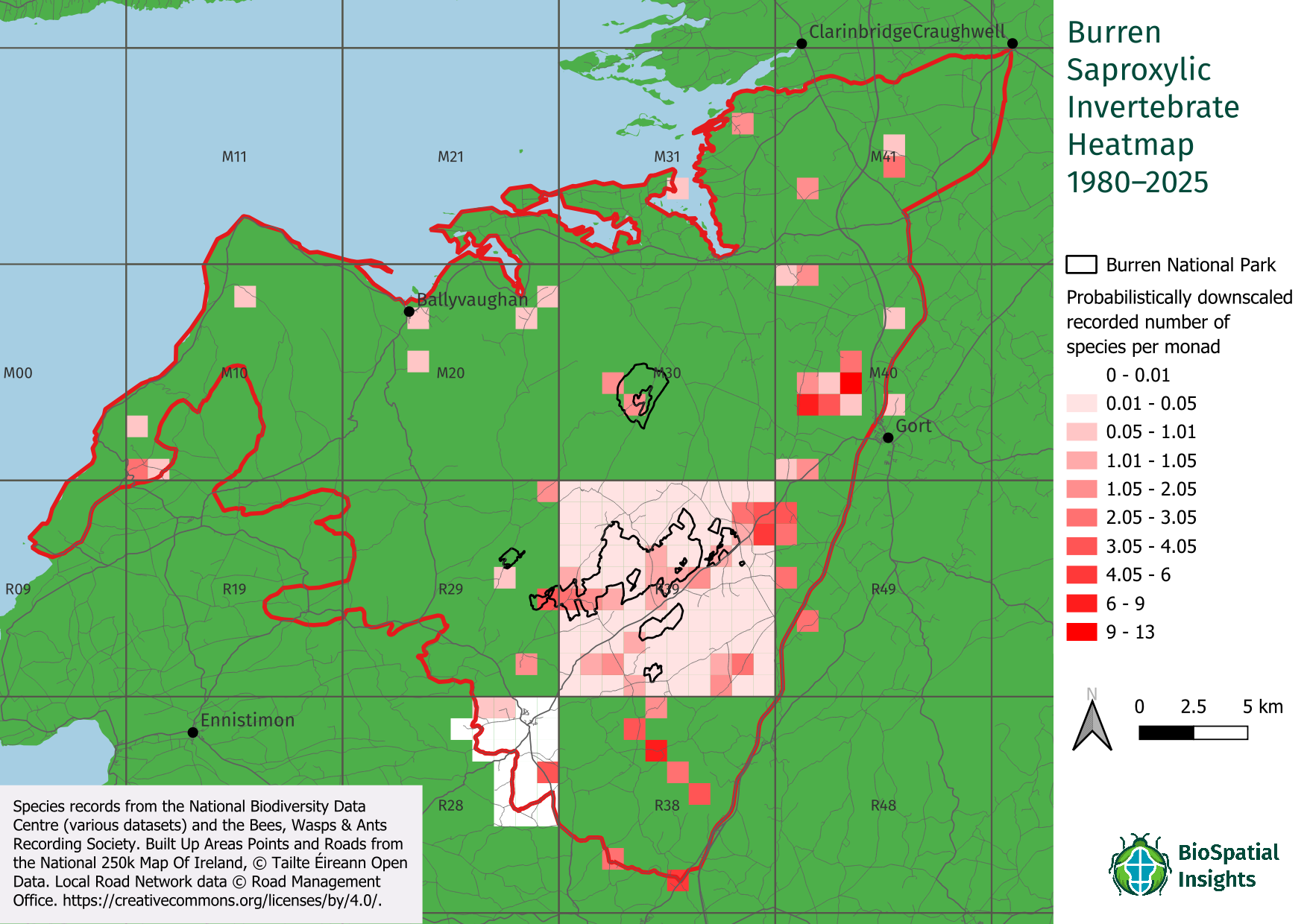
Heatmap for saproxylic invertebrates in the Burren.